उत्तर प्रदेश का भूगोल: स्थिति, क्षेत्र, map और study system
UP geography को केवल state boundaries या rivers की list की तरह पढ़ना पर्याप्त नहीं है। अच्छे questions में place, region, river, soil, agriculture, forest, history site और district clue एक-दूसरे से जुड़े होते हैं। इस article का लक्ष्य आपको वह base-map देना है जिस पर आगे rivers, districts, climate-agriculture, wildlife और history notes टिकें।
पहले उत्तर प्रदेश को map पर रखिए
Blank India outline में UP की rough position mark करें। फिर UP outline में उत्तर, दक्षिण, पूर्व और पश्चिम directions लिखें। Official state profile के अनुसार Uttar Pradesh northern India का एक बड़ा state है और Nepal इसकी northern boundary से जुड़ता है; बाकी neighbouring-state facts को map के साथ, latest official source से verify कर लिखें। Direction के बिना boundaries की list जल्दी भूलती है।
पाँच map anchors
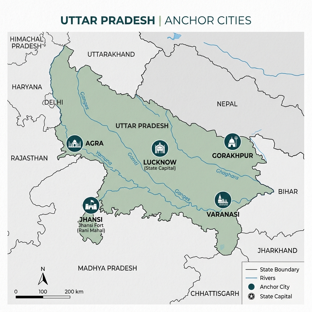
हर revision map में ये anchors पहले लगाएं: Agra, Lucknow, Varanasi, Gorakhpur और Jhansi। फिर Mirzapur/Sonbhadra side का south-eastern anchor लगाएं। ये cities geography, history, culture और administration को जोड़ने में मदद करती हैं। सभी districts पहली बार में map पर भरना लक्ष्य नहीं है।
region को broad context में पढ़ें
UP की geography को exam revision के लिए चार broad contexts में समझें। ये rigid textbook boundaries नहीं, memory frameworks हैं। Exact classification या official statistic हमेशा authoritative source से verify करें।
1. उत्तरी तराई और foothill context
Northern belt में Himalayan foothill/terai influence, forests, water, wildlife और flood-related geography जैसे clues मिल सकते हैं। जब कोई question northern protected area, wetland, forest habitat या Nepal-border context की बात करे, इस map zone को याद करें। Terai को पूरे northern UP का substitute न मानें; it is a specific environmental clue.
क्या लिखें: north-side position, water/forest connection, related districts/areas only after source verification.
2. गंगा-यमुना मैदानी context
State का large plain area river systems, fertile alluvial setting, agriculture, towns and dense settlement patterns से जुड़ा है। इसे “flat land” कहकर छोड़ना गलत है। River direction, floodplain, soil, cropping and transport questions इसी broad framework से समझे जा सकते हैं।
प्रमुख नदियाँ पढ़ते समय Ganga और Yamuna को केवल names न रखें; उनके आसपास के broad plain context और cities/regions को map पर देखें।
3. बुंदेलखंड context
Jhansi, Chitrakoot, Banda, Hamirpur, Mahoba और Lalitpur-side revision में Bundelkhand clue उपयोगी है। Terrain, water availability, history and regional identity से जुड़े questions के लिए इसे river-plain context में merge न करें। Jhansi/Chitrakoot divisions को जिले और मंडल से map पर फिर देखें।
Memory line: Bundelkhand → south-west side → plateau/terrain and regional-history clue.
4. विंध्य और दक्षिण-पूर्वी context
Mirzapur and Sonbhadra-side geography को Vindhya/plateau and south-eastern clues से पढ़ें। Forest, terrain, mineral or regional-resource questions में यह context अलग काम कर सकता है। Plains, terai और Vindhya-side notes को एक table में मिलाने के बजाय separate cards रखें।
नदी geography को map के साथ जोड़ें
किसी river के लिए पाँच fields रखें: river name, broad origin/source context, UP में broad flow side, associated region/city clue और why it matters (water, flood, irrigation, confluence etc.). Exact tributary or district facts source-verified note में जोड़ें।
| study question | सही approach |
|---|---|
| नदी का नाम दिया है | उसके broad UP region को याद करें |
| जिला/शहर दिया है | nearby river/physical context का clue देखें |
| flood/wetland लिखा है | northern/river-plain environment को consider करें |
| Bundelkhand/Vindhya लिखा है | plain-river answer को तुरंत assume न करें |
जिले और भौतिक क्षेत्र
District list केवल administration नहीं, geography revision का tool भी है। Agra-Mathura side, Lucknow-central context, Gorakhpur-eastern/northern context, Jhansi-Bundelkhand side और Mirzapur-Sonbhadra side को map clusters में पढ़ें। किसी district को region से जोड़ना useful है, लेकिन district boundaries/official current details हमेशा government source से verify करें।
geography, climate और agriculture connection
एक topic को दूसरे से अलग न पढ़ें:
- River/plain context → soil and agriculture discussion
- Northern terai context → water, forest and wildlife discussion
- Bundelkhand context → terrain, water and regional conditions
- Vindhya-side context → plateau/forest/resource clues
जलवायु, मिट्टी और कृषि note में यही second layer है। पहले इस article का map clear करें, फिर soil/crop facts पढ़ें।
State location और neighbouring map
UP को map पर समझने के लिए एक clockwise boundary drill करें। उत्तर में Nepal और Uttarakhand, पश्चिम/north-west की ओर Haryana और Delhi, south-west में Rajasthan, दक्षिण में Madhya Pradesh, पूर्व में Bihar और south-eastern side में Jharkhand context आता है। Boundary question में neighbouring state और direction दोनों साथ लिखें; केवल नामों की list पर्याप्त नहीं होती।
| direction | map association | note |
|---|---|---|
| north | Nepal, Uttarakhand | Terai/foothill and Himalayan river context याद रखें |
| west/north-west | Haryana, Delhi | NCR/western UP urban corridor clue |
| south-west | Rajasthan | western-southern boundary context |
| south | Madhya Pradesh | Bundelkhand/Vindhya transition side |
| east | Bihar | eastern Ganga plain and Purvanchal direction |
| south-east | Jharkhand | Sonbhadra-side edge context |
यह boundary map current administrative changes के लिए official map से check होना चाहिए, लेकिन broad state-neighbour direction geography foundation का stable part है।
Relief: UP flat नहीं है
UP को broad relief belts में पढ़ना सबसे उपयोगी है। Textbooks classification अलग words में दे सकती हैं, लेकिन नीचे का exam-oriented framework practical है।
| belt | location | terrain/formation clue | related topics |
|---|---|---|---|
| Bhabar | Himalayan foothill belt | coarse porous deposits, streams may sink | soil/foothill question |
| Terai | Bhabar के south का moist belt | marshy/moist, forests/grasslands, water-rich setting | agriculture, wildlife, flood risk |
| Gangetic plain | state का broad central expanse | flat alluvial plain, rivers and dense settlements | soil, agriculture, cities, transport |
| Bundelkhand upland | south-west | undulating/rocky plateau terrain | water stress, black/red soils, Jhansi-Chitrakoot |
| Vindhyan plateau | south-east | hills, plateau, forest/mineral-resource context | Mirzapur–Sonbhadra |
Bhabar and Terai same thing नहीं हैं: Bhabar foothill-side porous belt है; Terai उसके south का wetter low belt है। इसी तरह Bundelkhand और Vindhya दोनों “plateau” clues देते हैं, पर map side और local context अलग है।
Ganga-Yamuna plain: why it matters
Ganga-Yamuna plain only a flat surface नहीं, बल्कि river deposition, alluvial soil, agriculture, cities, transport routes और floodplain ecology का combined system है। इस system को पढ़ते हुए following chain याद रखें:
Himalayan/river catchment → sediment and river flow → alluvial plain → agriculture and settlement → flood/drainage challenge.
Prayagraj is the strongest confluence anchor: Ganga and Yamuna meet there, and the cultural-historical Sangam context also appears in other articles. But do not treat every river question as a Prayagraj question; Gomti, Ghaghara, Rapti, Ramganga, Betwa, Ken and Son-linked regional contexts अलग हैं।
Drainage by region: one-line understanding
| river-system clue | broad map context | what it helps answer |
|---|---|---|
| Ganga-Yamuna | central/western to eastern plains | confluence, alluvium, cities and agriculture |
| Ghaghara/Rapti | northern/eastern plain and Terai influence | floodplain and north-eastern drainage clues |
| Gomti | central-to-eastern UP | Lucknow and eastern flow-context questions |
| Betwa/Ken | Bundelkhand side | plateau/tributary and south-western geography |
| Son/Rihand side | south-eastern plateau | Sonbhadra/Vindhya resource-terrain context |
Exact tributary junction, source and district route must come from the dedicated major rivers guide. This table only tells you which physical-region card to open first.
Natural hazards और geography
Hazard questions become easier when linked to relief rather than memorised separately:
- Flooding/waterlogging: river plains, north-eastern/northern drainage and monsoon context.
- Erosion: active riverbanks/floodplain situations; exact district claims need official hazard source.
- Drought/water stress: Bundelkhand-side terrain and rainfall/water-management context.
- Forest/wildlife habitat: Terai and Vindhya/south-eastern terrain instead of central plain assumption.
Never write that an entire division has the same hazard. A district-level hazard map and the season/year matter for an exact answer.
Geography → other subjects: five example chains
- Terai → Dudhwa landscape → forest/wildlife → Bhabar–Terai soil context.
- Prayagraj → Ganga-Yamuna confluence → plain geography → Kumbh cultural context.
- Jhansi/Chitrakoot → Bundelkhand → plateau/water context → 1857 and folk-culture map.
- Mirzapur/Sonbhadra → Vindhya plateau → forest/mineral context → Chandra Prabha/Kaimur wildlife cards.
- Varanasi/Sarnath → eastern plain/city geography → ancient history and Banarasi culture.
These chains are why map practice is not a separate subject. A correct physical-region card improves history, culture, environment and agriculture answers together.
map practice: सात दिन का micro-plan
| दिन | काम | output |
|---|---|---|
| 1 | UP position और directions | blank outline with arrows |
| 2 | five city anchors | labelled map |
| 3 | four physical contexts | colour/label map |
| 4 | Ganga-Yamuna and two more river clues | river-direction sketch |
| 5 | Bundelkhand and Vindhya-side cards | two regional cards |
| 6 | districts/divisions cross-check | corrected map |
| 7 | बिना notes पूरा rough map | error list |
common mistakes
- पूरा UP एक जैसा plain मान लेना।
- River name याद होना लेकिन broad region/direction न पता होना।
- Terai, Bundelkhand और Vindhya-side contexts को mix करना।
- Historic place को geography map से अलग पढ़ना।
- Current statistic, boundary or administrative fact बिना date/source लिखना।
self-check questions
- Four broad physical contexts को map direction के साथ लिखिए।
- Jhansi and Mirzapur/Sonbhadra side को plain context से कैसे अलग करेंगे?
- River question हल करने से पहले कौन-से five fields देखेंगे?
- Geography, districts और agriculture notes को एक revision system में कैसे जोड़ेंगे?
आगे क्या पढ़ें?
इस map foundation के बाद क्रम रखें: प्रमुख नदियाँ → जिले और मंडल → जलवायु, मिट्टी और कृषि → forests/wildlife note. Import तभी होगा जब इस पूरे cluster की detailed review पूरी हो।
⚠️ यह note परीक्षा तैयारी के लिए है। भर्ती, तारीख या आधिकारिक सूचना के लिए संबंधित विभाग की official website ही अंतिम स्रोत है।