उत्तर प्रदेश की जलवायु, मिट्टी और कृषि: region से crop तक समझें
UP की कृषि को गेहूँ–धान की list की तरह पढ़ना आसान है, पर objective question में बात वहीं नहीं रुकती। वह पूछ सकता है: किस soil belt का clue है? कौन-सा crop season? किस region में water/terrain अलग है? या किस crop को irrigation/winter/monsoon से जोड़ेंगे? इसलिए सही chain है:
physical region → rainfall/temperature/water setting → soil → crop season → crop example → irrigation/river context।
यह guide stable concepts देती है। उत्पादन, सबसे बड़ा उत्पादक district, procurement price, rainfall figure या current scheme जैसे changing data को current official agriculture/statistics source से ही verify करें।
UP की broad climate identity
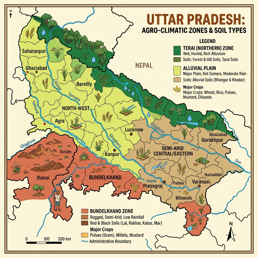
उत्तर प्रदेश broadly tropical monsoon climate zone में आता है। गर्मी, मानसून और सर्दी के distinct seasonal phases कृषि cycle को प्रभावित करते हैं। फिर भी पूरे state में same rainfall, same soil या same irrigation condition नहीं है। Northern terai, central Ganga plain, Bundelkhand और Vindhya/south-eastern plateau अलग study contexts हैं।
| region | physical clue | agriculture/soil understanding |
|---|---|---|
| northern terai | Himalayan foothill-side, high moisture, forest/grassland | wet/moist landscape, rich alluvial-terai soil context |
| Ganga-Yamuna plain | broad river plains and alluvium | intensive farming, alluvial soils and irrigation networks |
| Bundelkhand | rocky/undulating plateau, variable water availability | black/red-mixed soil context; drought/water management questions |
| Vindhya/south-east | plateau, hills, forest, red/yellow soil contexts | plains से अलग terrain and agriculture pattern |
इस table का उपयोग city/district stereotypes बनाने में न करें। एक district में भी local variation हो सकती है; exam में broad regional clue से option eliminate करना लक्ष्य है।
मौसम और कृषि cycle
गर्मी (लगभग मार्च से जून)
गर्म season में तापमान बढ़ता है और कई parts में dry conditions दिखती हैं। पश्चिमी गर्म शुष्क हवाओं के लिए “लू” word अक्सर आता है। यह season land preparation, irrigation need और Zaid crops के context में useful हो सकता है। Exact temperature record या heatwave severity current weather data है, static GK नहीं।
मानसून (लगभग जून से सितंबर)
South-west monsoon rainfall का main source है और Kharif agriculture के लिए critical है। East–west या region-wise rainfall variation को एक universal number से replace न करें। Monsoon questions में floodplain, drainage, wetland, river basin और waterlogging जैसे related concepts आ सकते हैं।
शीत ऋतु (लगभग नवंबर से फरवरी)
Winter Rabi crops की growth context देता है। Western disturbances rainfall/temperature patterns पर प्रभाव डाल सकते हैं, पर basic UP GK answer में first priority Rabi season और cool weather है। Frost, fog या cold-wave details location/year sensitive हैं; source-date के बिना absolute fact न लिखें।
कृषि seasons: पहले season, फिर crop
| season | basic timing/context | main crop examples | question trap |
|---|---|---|---|
| Kharif | monsoon onset/monsoon cycle | धान, मक्का, बाजरा, ज्वार, अरहर, सोयाबीन, गन्ने का annual cycle context | हर water-related crop को Kharif मान लेना |
| Rabi | winter sowing/cool season | गेहूँ, जौ, चना, मटर, मसूर, सरसों | Rabi को केवल गेहूँ का synonym मानना |
| Zaid | Rabi और Kharif के बीच, summer with irrigation | तरबूज, खरबूज, खीरा, कुछ vegetables/fodder | इसे एक crop का fixed season मानना |
गन्ना एक long-duration commercial crop है, इसलिए इसे simple “केवल Kharif या केवल Rabi” binary में फिट करना गलत हो सकता है। Question wording देखिए: यदि sowing season पूछे तो authoritative agriculture source से exact regional practice verify करें; यदि broad crop pattern पूछे, sugarcane को cash crop/long-duration crop context में रखें।
मिट्टी: location और origin से याद करें
1. जलोढ़ मिट्टी (Alluvial soil)
UP के बड़े Ganga-Yamuna plain में alluvial soil सबसे important study anchor है। नदी द्वारा लाई और जमा की गई sediments से जुड़ी यह मिट्टी खेती के लिए generally fertile context देती है। river plains → deposition → alluvial soil → intensive agriculture यह chain याद रखें।
Alluvial soil के भीतर Bhangar और Khadar terms objective exams में मिलते हैं:
| term | easy clue | common error |
|---|---|---|
| Bhangar | older alluvium, comparatively higher terraces | इसे नया flood deposit कहना |
| Khadar | newer alluvium, floodplain-side deposition | इसे Bhangar का synonym मानना |
किस particular district में कौन-सी category dominant है, ऐसा detailed claim map/source के बिना न करें। Basic distinction origin and relative age का है।
2. Bhabar और Terai belt
नेपाल सीमा के निकट foothill belt में Bhabar और Terai terms आते हैं। Bhabar generally coarser, porous material/pebbly belt के clue से पढ़ी जाती है; उसके south की Terai belt moisture, marshy/vegetation-rich conditions और finer deposits के context में आती है। Exam shortcut:
foothill porous belt → Bhabar; moist low-lying belt south of it → Terai.
Terai को only “soil type” या only “forest zone” न मानें; वह terrain, moisture, agriculture और wildlife—सभी से जुड़ा regional context है। Dudhwa landscape को इसी northern belt से जोड़ने के लिए वन और wildlife guide उपयोगी है।
3. Black soil और Bundelkhand context
Bundelkhand side में black soil/black cotton soil (regur) references मिल सकते हैं, especially basaltic/plateau-related contexts में। इसका most important exam clue है moisture retention and cotton association—लेकिन पूरे Bundelkhand को one uniform black-soil sheet न लिखें। वहाँ red, mixed और rocky conditions भी local level पर मिलती हैं।
यदि question black soil, regur, cotton, moisture retention कहे, तो black soil card खोलें। यदि question Jhansi–Banda–Chitrakoot/Lalitpur terrain कहे, पहले Bundelkhand/plateau context, फिर soil option check करें।
4. Red and yellow soils: Vindhya/south-eastern context
Mirzapur, Sonbhadra और adjoining Vindhya-side plateau discussions में red/yellow soil context दिखाई दे सकता है। Iron compounds के कारण red/yellow colour clues पढ़े जाते हैं। ये soils broad Ganga alluvial plains की same profile नहीं हैं। Dry deciduous forest, plateau slope, mineral/resource geography और rain-fed agriculture questions के साथ map relation बनाइए।
5. Usar/alkaline or saline soil problem
कुछ plain areas में alkaline/saline soils को usar problem context में पढ़ा जाता है। यह “UP की पूरी मिट्टी” नहीं, soil-quality/land-reclamation question का clue है। Alkali reclamation, gypsum, drainage या soil management जैसी detail syllabus/source के अनुसार पढ़ें; बिना context के हर low-yield area को usar कहना गलत है।
Crop-region reasoning: example, not rigid district claim
| crop/category | first study context | second check |
|---|---|---|
| गेहूँ | Rabi, winter/cool season | irrigation and alluvial plains can be relevant |
| धान | Kharif/monsoon and water need | region and irrigation/rainfall condition |
| गन्ना | cash/long-duration crop | water and processing/industry context |
| दलहन | Rabi/Kharif examples vary by crop | exact crop-season pair |
| तिलहन | सरसों as Rabi example; others vary | crop-specific season |
| बाजरा/ज्वार | Kharif and lower-rainfall/drier context clues | do not ignore local practice |
जिले के “largest producer” facts frequently change or differ by dataset/year. उन्हें evergreen study article में नहीं रखना intentionally better है। Aspirant को first understanding चाहिए कि crop season और environment से कैसे जुड़ता है; current rankings separate dated current-affairs card में जाएँ।
सिंचाई: river होने से हर field irrigated नहीं हो जाती
UP agriculture में canals, tube wells, wells, pumps और other irrigation systems महत्वपूर्ण हैं। लेकिन question में Ganga/Yamuna/Ghaghara river का नाम होना automatically irrigation answer नहीं है। पहले देखें कि question river basin, canal system, groundwater, crop water requirement या flood risk किस angle से पूछ रहा है।
| clue | सही thought process |
|---|---|
| broad plain and intensive farming | alluvium + irrigation availability + crop season |
| floodplain/wetland | drainage/flood/water ecology, not automatic crop record |
| Bundelkhand drought/water concern | terrain, rainfall variability and water management |
| canal/tube-well | irrigation method, not soil category |
35-minute revision drill
- चार-region map बनाइए: Terai, Ganga plain, Bundelkhand, Vindhya/south-east।
- हर region के सामने one soil and one agriculture clue लिखिए।
- तीन season cards लिखें और crop examples जोड़ें।
- Bhangar–Khadar, Bhabar–Terai, Tehsil–Block जैसे similar-pair cards अलग रखें—यह exam में common pattern है।
- एक blank page पर answer लिखें: “UP में alluvial plain और Bundelkhand agriculture context में कैसे अलग हैं?”
Common mistakes
- Alluvial soil को state की हर जगह की soil मानना।
- Bhangar और Khadar की age/location उलटी लिखना।
- Bhabar और Terai को same belt without difference कहना।
- गन्ने को short single-season crop की तरह classify करना।
- सभी pulses/oilseeds को एक ही crop season देना।
- annual production figure या crop ranking को source/date के बिना publish करना।
Self-check
river deposition → ______ soil? जलोढ़/alluvial।- Newer floodplain alluvium? Khadar।
- Foothill porous belt और उसके south का moist belt? Bhabar और Terai।
- गेहूँ, धान, तरबूज—इनके broad season cards? Rabi, Kharif, Zaid।
- Black soil–regur clue किस broader region में याद करेंगे? Bundelkhand/plateau-side context।
अब UP भौगोलिक क्षेत्र, प्रमुख नदियाँ और वन/संरक्षित क्षेत्र को साथ पढ़ें। इन तीनों से climate-soil-agriculture facts isolated नहीं रहेंगे।
⚠️ यह note परीक्षा तैयारी के लिए है। भर्ती, तारीख या आधिकारिक सूचना के लिए संबंधित विभाग की official website ही अंतिम स्रोत है।